Neuf-Brisach
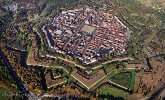
Neuf-Brisach is a town in the shape of an eight-pointed star, 20 km east of Colmar on the Rhine. It was designed on a blank field by Vauban in 1698, built in one operation, and it has never been altered.
It is the last and the most complete of Vauban’s works, and it was UNESCO-listed in 2008 as part of the group of twelve fortifications across France.
Why it exists
The Treaty of Ryswick in 1697 forced Louis XIV to give up Vieux-Brisach on the right bank of the Rhine, which had guarded the crossing. He needed a replacement on the French side, and gave the job to Vauban, then 65 and at the end of his career.
Vauban submitted three designs; the king chose the third. Construction began in 1698 and the town was finished in 1702 — a complete fortress, garrison town and civilian settlement built from nothing in four years.
Star forts
Fortifications in this angular, star-shaped form became the standard answer once artillery made the high walls of a medieval castle indefensible: a low profile built of earth and brick withstood cannon fire far better than tall stone, and deep ditches combined with fire along the length of the walls turned the ground in front of an attacker into a killing zone. The type was common across Europe at the time — the old town of Lucca, in Italy, has walls of a similar shape — and models of comparable fortresses can be seen at the Musée des Plans-Reliefs in Paris.
Vauban
Sébastien Le Prestre de Vauban, later marquis de Vauban, served in every war fought under Louis XIV. He is generally ranked, alongside his Dutch contemporary Menno van Coehoorn, as the outstanding military engineer of the age: his fortification principles remained the standard for close to a century, and his methods of siege attack stayed in use into the twentieth century. He also founded a royal military corps, and is credited with creating combat-engineering units within the French army.
Away from fortress work, Vauban was involved with several French ports and with civilian projects such as the Canal de la Bruche. Shortly before his death in 1707 he published La Dîme royale, a tract arguing for a fairer distribution of the tax burden and backing the case with statistics — work that has led some historians to count him among the forerunners of modern economics.
The design
The plan is the point, and it is best understood from the air or from the ramparts:
- An octagon, with a bastioned tower at each corner and a demi-lune before each face — Vauban’s third and most developed system
- Inside, a grid: 48 identical square blocks around a central place d’armes, with the church, the governor’s house and the barracks in fixed positions
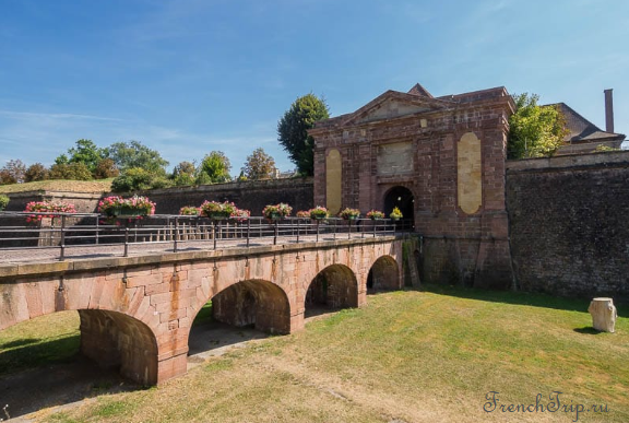
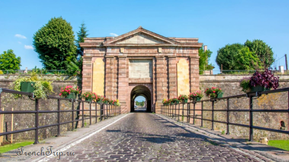
- Four gates, one on each cardinal side, of which the Porte de Belfort survives complete with its guardrooms
- Two kilometres of rampart, moats and outworks, walkable right round
The fortifications work in two layers: an inner enceinte de sûreté, the bastioned wall immediately around the town, and an outer enceinte de combat, a system of concentric earthworks in the shape of a star that covers a much larger area than the inner wall alone. Ahead of each stretch of curtain wall sits a tenaille and, beyond it, a counterguard; a large quadrangular ravelin protects the centre of each curtain, and the ravelins before the gates are themselves crowned with redoubts facing backwards. A covered way runs around the outside of the whole system of earthworks.
The street plan followed the contemporary idea of the “ideal city”. Individual blocks inside the grid were allotted to private owners, either as gardens or for commercial letting, while plainer housing was grouped into long terraces built against each defensive wall — an additional buffer against artillery fire in front of the grander houses further in.
The military logic is visible everywhere: every wall covers another wall, no attacker can approach without being fired on from two directions, and the interior streets let a garrison move to any point at speed.
What to do
- Walk the ramparts — about an hour for the full circuit, free, and the only way to grasp the geometry from the ground
- Musée Vauban in the Porte de Belfort — models, plans and the history of the construction
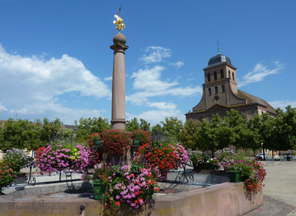
- The church of Saint-Louis, on the central square, built 1731–36 to the original plan
- The tourist train round the outworks in season, which covers ground the walk does not
- The other three gates — Porte de Colmar, Porte de Strasbourg and Porte de Bâle — are named after the towns and the border they face
- The fountain on the main square was the town’s largest reserve of water against fire; the original was destroyed in 1870, and the current fountain, an exact copy, dates from 1992
- The town hall — the first one, built in 1700, was of timber and about half the size of the present building
- A Protestant church, built in the nineteenth century, also stands in the town
- The central square doubled as a parade and drill ground for the garrison and, off duty, hosted large food and livestock markets
Be clear about what this is: an exercise in seventeenth-century engineering rather than a pretty Alsatian town. The interior is plain by design — Vauban was building a machine, not a picture — and the pleasure is in reading the plan.
Siege and war
Neuf-Brisach has been fought over more than once despite the engineering. Prussian forces bombarded and captured the town in 1870; the artillery commander defending it, Michel Marsal, was killed during the siege, a loss that badly damaged morale among the garrison and the townspeople.
In 1945 American forces shelled Neuf-Brisach, killing a number of people, without first establishing whether German troops remained inside. A local man, Émile Muller, tried to stop the bombardment under a white flag and was badly wounded, but he managed to signal the Americans a way into the town, which is credited with saving Neuf-Brisach from being destroyed outright.
Getting there
- By car — 20 minutes from Colmar, on the road to the Rhine and Freiburg. See parking in France.
- By bus — services from Colmar.
- By bicycle — the EuroVelo 15 Rhine route passes close by, and the flat Alsace plain makes this easy from Colmar.
Around
- Breisach — the German town across the Rhine that Neuf-Brisach replaced, with its cathedral on a hill; ten minutes and a border crossing
- Colmar — 20 km, and the base for this corner of Alsace
- The wine route — 30 minutes west, in the other direction entirely
- Rhine nature reserves — the wet forest along the river, with birds and cycle paths
When to go
April to October. The rampart walk is exposed and there is no shade; spring and autumn are more comfortable than midsummer. An hour and a half covers the town; combine it with Colmar or with a crossing into Germany.
See Alsace and UNESCO sites in France.
Nearby
Other places on this site within easy reach, as the crow flies:
- Colmar — 14 km
- Eguisheim — 17 km
- Rouffach — 18 km
- Turckheim — 20 km
- Katzenthal — 21 km
- Riquewihr — 24 km
Weather in Neuf-Brisach
| Month | Day | Night | Rainfall |
|---|---|---|---|
| January | +6° | -1° | 33 mm |
| February | +8° | -1° | 31 mm |
| March | +13° | +2° | 34 mm |
| April | +17° | +5° | 43 mm |
| May | +21° | +10° | 70 mm |
| June | +25° | +13° | 66 mm |
| July | +27° | +15° | 63 mm |
| August | +27° | +14° | 61 mm |
| September | +22° | +10° | 51 mm |
| October | +16° | +7° | 57 mm |
| November | +10° | +3° | 44 mm |
| December | +6° | 0° | 43 mm |
This page in Russian: Neuf-Brisach (Нёф-Бризах)
Updated: