Cassis
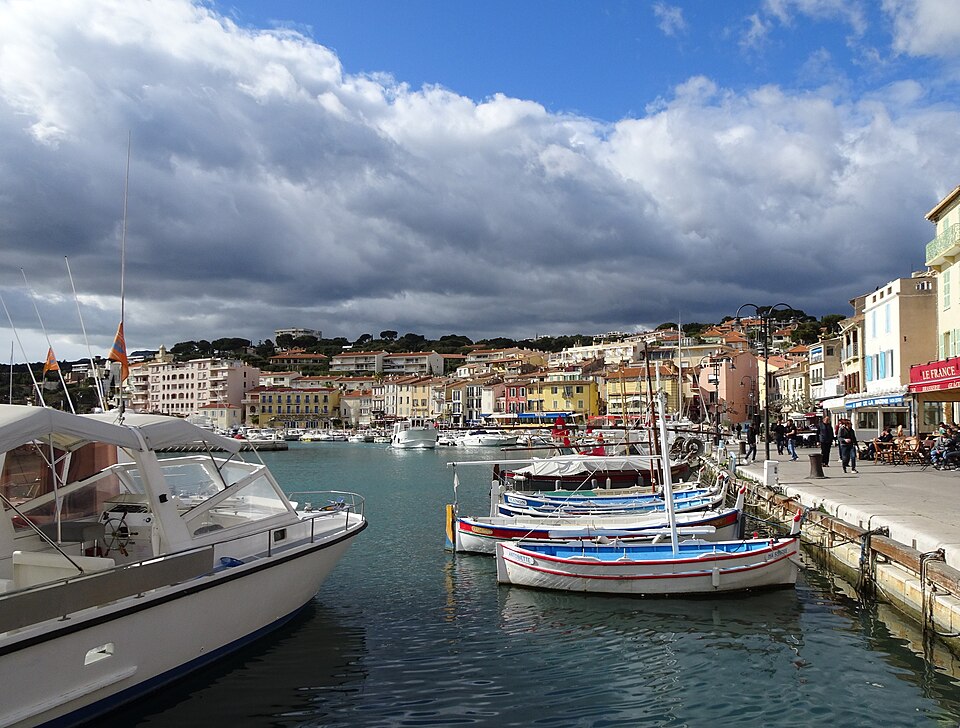
Cassis is a fishing village turned resort just east of Marseille, wedged between two extremes: the Calanques, the white limestone inlets to the west, and Cap Canaille, the highest sea cliff in France, to the east. Between them sit a harbour of ochre and pink houses, terraced vineyards and pine woods.
Painters came for the light — Braque, Signac, Dufy and Derain all worked here — and Frédéric Mistral gave the town the line it has been quoting ever since: whoever has seen Paris and not seen Cassis has seen nothing.
The Calanques
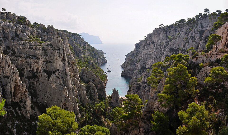
The reason most people come. The calanques are steep-sided inlets cut into white limestone, filled with water of an improbable turquoise — drowned river valleys, effectively fjords in miniature, running for 20 km along the coast to Marseille. The whole stretch has been a national park since 2012.
The three nearest Cassis, in order of effort:
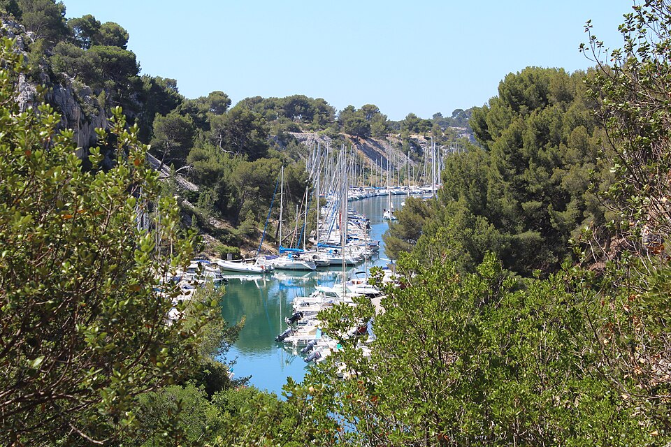
- Port-Miou — 20 minutes’ walk from the town, long and narrow, now a natural marina full of moored boats. No beach, but the easiest to reach.
- Port-Pin — another 20 minutes on, small, with pines coming down to a pebble beach. The best swim for the effort.
- En-Vau — the famous one: a narrow gorge between vertical white walls with a small beach at the end. An hour and a half on foot from Cassis, with a steep, rough descent at the end. Proper shoes, plenty of water, and not in the heat of the day.
By boat is the alternative and takes no effort at all: operators run from the harbour, from about 45 minutes for three calanques up to a couple of hours for eight or nine. Most only sail past; check whether yours stops for a swim. Kayak trips are the third option, and the best one.
Important: the massif closes to walkers on days of high fire risk, most often in July and August, and the decision is made the evening before. Check the prefecture’s daily access map before setting out, or you will walk to a locked barrier.
The access map grades each sector on a three-colour scale: orange, and the calanques are open as usual; red, and only the early hours before the day heats up are open, with the rest of the day closed; black, and the sector is shut outright. Different calanques can carry different colours on the same day, so check the one you actually plan to visit rather than the general picture.
Cap Canaille
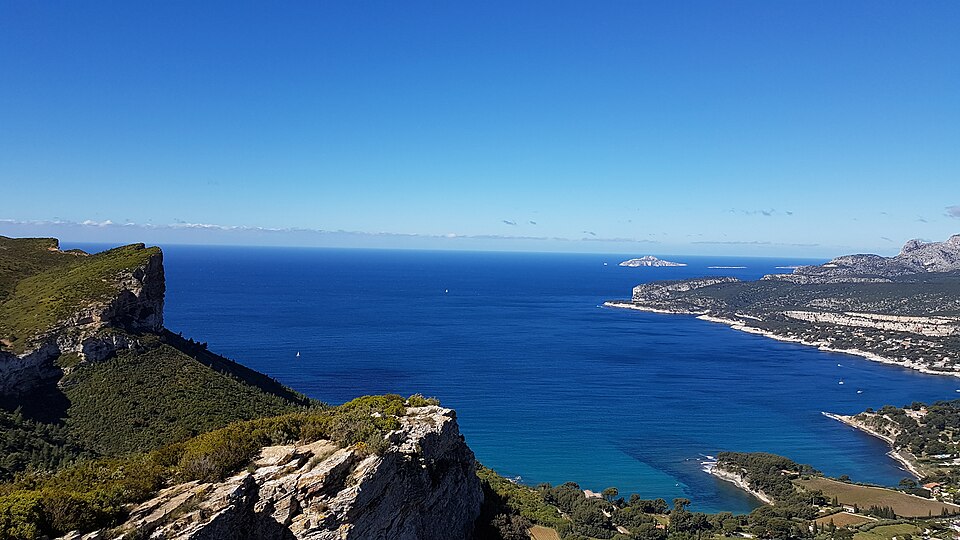
The other side of the bay: a wall of ochre and red rock rising 394 m straight out of the sea — the highest sea cliff in France. The Route des Crêtes runs along the top from Cassis to La Ciotat, 15 km of viewpoints with the whole coast underneath. It is one of the great drives in France, and it also closes in high wind and fire risk.
Beaches
Most of the shoreline at Cassis is rock shelf rather than sand, and much of the swimming happens in the calanques themselves — Port-Pin and En-Vau both have small beaches of their own. In town, two spots are worth knowing:
- Plage de Bestouan — pebble, a short walk west of the harbour, the only beach in Cassis with Blue Flag status. Lifeguards in season, no dogs.
- Plage de la Grande Mer — sand, right in the centre next to the main car park. The easiest to reach and the one families use, and crowded with it in summer.
Beyond those, the rocky shore past Port-Miou known locally as “Plage Bleue” gives a view back over the bay rather than a swim — there is no sand and the water is awkward to reach — and a further small cove nearby is known locally as a gay and naturist beach.
The town
Small, and the pleasure is the harbour front and the streets behind it. Specific things to look for:
- The oratories — Cassis belonged to the bishops of Marseille before the Revolution and was a notably devout place. Eleven roadside oratoires survive: pointed niches in walls with a wrought-iron cross above and, in some, the original statue of a saint. They are easy to walk past and they are the town’s oddest inheritance.
- Chapelle de l’Hôtel de Ville — 1649, on the first floor behind the mayor’s office, with a richly worked ceiling and an old crucifix over a stone altar. Listed, and open only on heritage days.
- Notre-Dame de Santé — built in thanksgiving after a plague epidemic, and still the object of a procession on the first Sunday of July that starts at four in the morning and ends at sunrise.
- Église Saint-Michel — the parish church of 1875, neo-Romanesque, three naves.
- Château de Cassis — the medieval castle on the headland above the port, now a private hotel, but it defines the skyline.
- Fontaine des Quatre Nations — the fountain on the harbour front is a modern copy of one built in 1690 in homage to a Paris monument celebrating Louis XIV’s victories. Visitors from Paris were said to joke that whoever had seen the fountain there had seen nothing until they saw the one in Cassis — the line Mistral later reworked into the town’s motto about Paris itself. Local tradition holds that the original did not survive: a fisherman climbing it in 1785 for a better view of a summer festival broke it.
- Tribunal de Pêche — the fish court on the quai Barthélemy, a reminder that Cassis fought for and won its own jurisdiction over fishing disputes, separate from Marseille’s, in 1791. A wooden statue of St Peter, patron of the fishing guild, stands in a niche on the façade and is carried to the church each year for the Saint-Pierre festival at the end of June.
- Musée d’Arts et Traditions Populaires — a small museum by the port, in a former presbytery dating from the early 17th century, austere outside and characterful within. The collection runs from Roman-era amphorae to paintings, the oldest from 1601.
The castle is older than it looks from the harbour: a fortress of the 13th or 14th century, probably built on an 8th-century predecessor, held from 1232 by the Les Baux family, who also controlled Aubagne and Roquefort. Medieval Cassis grew up inside its walls, and by the late 15th century more than 250 people lived within them. Troops of Charles V — the Holy Roman Emperor, not a French king — took the castle in 1524, after which the town shifted down to the waterside and became a working port instead. The adjoining Villa Mauresque, built in the early 20th century in a style borrowed from colonial Algiers, was bought along with the castle by an American who had fallen for the town; the municipality acquired it in 1979 and it remains closed for restoration.
Fondation Camargo — an artists’ residency founded in 1967 by Jerome Hill, an American painter and heir to a railway fortune, who first came to Cassis to study painting and later bought land next to the house of an English painter who taught art locally — one of her pupils, according to local lore, was Winston Churchill. Each year the foundation hosts around a dozen fellows — painters, writers, composers, photographers — for working stays, with a library, a music room and a darkroom on site.
The wine
Cassis was one of the first appellations in France, recognised in 1936, and its whites — Marsanne, Clairette and Ugni Blanc on terraces above the sea — are generally reckoned the best in Provence. The appellation is tiny, about 200 hectares squeezed between the town and the cliffs, so almost none of it leaves the region. Drink it locally with fish; that is the entire point.
Note for the confused: this has nothing to do with crème de cassis, the blackcurrant liqueur, which comes from Burgundy. Same word, different thing.
See French wines.
Festivals
The Fête des Pêcheurs (Day of the Fishermen and the Sea), on the last weekend of June, centres on a Sunday-morning blessing at Église Saint-Michel in honour of St Peter, followed by a procession down to the port and a blessing of the boats at sea.
The Fête du Vin et des Vendanges, on the last weekend of September, marks the grape harvest: a Mass said partly in Provençal, folk dancing outside the church afterwards, a parade in traditional dress, and tastings poured by the Cassis winemakers themselves.
Cassis also runs a Christmas market over the ten days before the holiday, when the harbour front is dressed for the season.
Getting to Cassis
- By train — about 25 minutes from Marseille, but the station is 3 km outside the town and uphill, which catches people out. A shuttle bus meets the trains; walking back up at the end of the day is unpleasant.
- By bus — direct services from Marseille (Castellane) take about an hour and drop you in the centre. Often the better option.
- By car — 30 minutes from Marseille on the A50. Parking is the problem: the centre is closed to traffic in season and the car parks above the town fill by mid-morning. Come early or come by bus. See parking in France.
- By air — Marseille-Provence, about 50 minutes.
What to eat
Fish and shellfish from the harbour, sea urchins in winter, bouillabaisse, and the local white to go with all of it. The restaurants along the quay charge for the view; the ones a street back do not. See Provençal cuisine.
Around Cassis
- La Ciotat — the next town east along the Route des Crêtes, with the world’s oldest working cinema
- Marseille — 30 minutes, and the Calanques continue all the way there
- Aix-en-Provence — 45 minutes north
- Bandol — the other serious Provençal appellation, half an hour east
When to go
May, June and September. The calanque walks are unpleasant and often closed in high summer, the town is packed, and parking is impossible. Spring is best: the water is cold but the paths are open and the cliffs have their colour. Winter is quiet and many restaurants shut.
See the natural sights of Provence and the best beaches in the region.
Photo credits
Photographs on this page come from Wikimedia Commons under free licences:
- The harbour of Cassis — Celeda, CC BY-SA 4.0, via Wikimedia Commons
- Calanque d’En-Vau — Tobi 87, CC BY-SA 3.0, via Wikimedia Commons
- Calanque de Port-Miou — Chabe01, CC BY-SA 4.0, via Wikimedia Commons
- Cap Canaille and the bay — Mathieu Brossais, CC BY-SA 4.0, via Wikimedia Commons


Where to park in Cassis
| Car park | Spaces | Fee | From centre |
|---|---|---|---|
| Parking de la Poste | 120 | paid | 90 m |
| Parking des Mimosas multi-storey | 404 | paid | 260 m |
| Parking de la Madie | — | paid | 500 m |
| Parking Daudet | 89 | paid | 570 m |
Nearby
Other places on this site within easy reach, as the crow flies:
- La Ciotat — 7 km
- Calanques — 10 km
- Marseille — 16 km
- Toulon — 33 km
- Aéroport de Marseille — 36 km
- Martigues — 45 km
Weather in Cassis
| Month | Day | Night | Rainfall |
|---|---|---|---|
| January | +13° | +6° | 58 mm |
| February | +14° | +6° | 41 mm |
| March | +17° | +8° | 34 mm |
| April | +19° | +10° | 66 mm |
| May | +23° | +13° | 47 mm |
| June | +28° | +17° | 24 mm |
| July | +30° | +19° | 10 mm |
| August | +30° | +20° | 23 mm |
| September | +26° | +16° | 79 mm |
| October | +22° | +14° | 90 mm |
| November | +17° | +10° | 83 mm |
| December | +14° | +7° | 60 mm |
This page in Russian: Кассис (Cassis)
Updated: